Nasa's Curiosity rover, also known
as the Mars Science Laboratory (MSL), is celebrating 2,000 martian days
(sols) investigating Gale Crater on the Red Planet. In that time, the
robot has made some remarkable observations. Here are just a few of
them, chosen by the Curiosity science team.
Image copyrightNASA/JPL-Caltech/MSSSLooking back: In the history of the
space age, some of the most dramatic planetary images ever taken have
been of Earth, but photographed looking back from deep space. This image
by Mastcam on the Curiosity Rover shows our planet as a faint pinpoint
of light in the martian night sky. Every day scientists from across the
world drive the Curiosity rover and study the Red Planet about 100
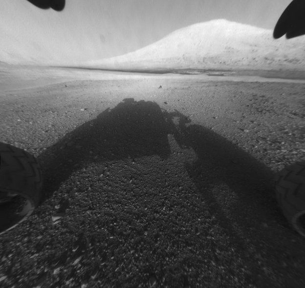
million miles from Earth. Image copyrightNASA/JPL-CaltechThe beginning: The first image that
Curiosity took came back just 15 minutes after landing on 5 August
2012. Getting our imagery and other data relies on the timing of Mars
Reconnaissance Orbiter (MRO) overpasses, a pattern which determines the
structure of the martian working day, or sol. It shows a grainy Front
Hazard Camera image - the team normally use these to help avoid
obstacles - of our ultimate goal Mount Sharp. When this image came back
we knew it was going to be a successful mission. Image copyrightNASA/JPL-Caltech/MSSSRiver pebbles: Once we had started
driving (16 sols after landing), we soon came across these pebble beds.
The rounded shape of the clasts shows that they formed in an ancient,
shallow river, flowing from the surrounding four-billion-year-old
highlands into Gale Crater. The inset Mastcam image shows one of the
pebbles in close-up. Contrary to our expectations before MSL, the crust
being eroded by the rivers was not all dark, primitive basalt but a more
evolved composition and mineralogy. Pebbles caught up in this ancient
martian river are causing us to rethink our view of how the underlying
igneous crust and mantle of Mars formed. Image copyrightNASA/JPL-CaltechAncient lake: Before landing and in
the early part of the mission, the team wasn't sure what all of the
terrains identified from MRO HiRISE orbital imagery were. They might
have been lava flows or lake sediments, without close-up "ground truth"
it was impossible to be certain. This image settled the debate and was a
seminal stage in Martian exploration. Yellowknife Bay is made of layers
of fine grained sand and muds, which were deposited as rivers flowed
into an ancient Gale Crater lake. We made our first of 16 drill holes on
sol 182 - we do this to get rock in to the spectrometers housed in the
body of our rover - here at the John Klein site. The results - including
identifying clays, organics and nitrogen-bearing compounds - showed us
that this had been a habitable environment for microbial life. The next
discovery step - Was There Life? - remains to be determined.
Image copyrightNASA/JPL-Caltech/MSSSDeep water: The Pahrump Hills
section Curiosity encountered around sol 753 was key for developing our
understanding of Gale's past environment. Here the rover observed thinly
layered mudstones, which represented mud particles settling out from
suspension within the deeper lake. The Gale Lake has been a
long-standing, deep body of water. Image copyrightNASA/JPL-Caltech/MSSSAn unconformity: At Mount Stimson,
the rover identified from sol 980 a thick sandstone unit overlying the
lake deposits, separated by a geological feature called an unconformity.
This unconformity represents a time where erosive processes took over
after millions of years when the lake had finally dried up - to form a
new land surface. This shows evidence of events happening over "deep
time", similar to those that the pioneering geologist James Hutton
described in his field work in the late 18th Century at Siccar Point on
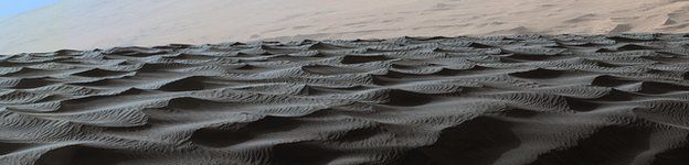
the Scottish Coast. Image copyrightNASA/JPL-Caltech/MSSSDesert sands: The Namib dunes
encountered close up by Curiosity at sol 1192 is a small part of the
great Bagnold dune field. Its the first active dunefield explored on the
surface of another planet and Curiosity had to pick its way carefully
along and through the field as moving sands are an obstacle for rovers.
Although the Martian atmosphere is a fraction of the density of that of
Earth's, it is still capable of transporting sediment and is capable of
creating such beautiful structures akin to those we see in the deserts
of Earth. Image copyrightNASA/JPL-Caltech/MSSSWind sculptures: The Murray Buttes,
photographed by Mastcam on sol 1448, formed of the same sandstones
observed at Mount Stimson and represent a lithified dune field created
by dunes similar to those in the present day Bagnold dune field. These
desert-formed sandstones sit above an unconformity, and this suggests
that after a long period with a humid climate, the climate became drier
and wind became the dominant agent shaping the environment at Gale
Crater. Image copyrightNASA/JPL-Caltech/LANL/CNES/IRAP/LPGNantes/CNRS/IASDried muds: Curiosity is able to
perform detailed analyses of the Gale rocks with the ChemCam laser and
telescope mounted on its mast. Here on sol 1555 at Schooner Head we came
across a set of ancient mudcracks and sulphate veins. On Earth, lakes
typically dry up in places around their margins and here on Mars the
Gale lake was no different. You can see the red crosses where we fired
the laser at the rock, creating a small plasma spark, with the
wavelength of light in the spark telling us the composition of the
mudstone and veins Image copyrightNASA/JPL-CaltechCloudy skies: This sequence of
images was taken with Curiosity's Navigational Cameras (NavCam) on sol
1971 as we pointed them towards the sky. Occasionally on the cloudiest
of Martian days we are able to make out faint clouds in the sky. These
images are processed to highlight differences, allowing us to see the
clouds move across the sky. This sequence shows previously unseen cloud
features with prominent zig-zag patterns visible. The three images, from
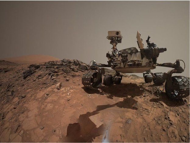
start to finish, cover approximately 12 minutes on Mars. Image copyrightNASA/JPL-Caltech/MSSSObligatory 'selfie': The Curiosity
rover has gained a reputation over the years that rivals those of
Instagram users for its many "selfies" taken along its traverse. These
selfies are not all for show though as they help the team track the
state of the rover throughout the course of the mission for changes such
as wheel wear and dust accumulation. Curiosity's self-portraits are
taken using the rover's Mars Hand Lens Imager (MAHLI) situated on its
robotic arm and are generated by merging a series of high-resolution
images into a mosaic. This one taken on sol 1065 at the Buckskin
locality shows the main mast of Curiosity with its ChemCam telescope
used to determine rock compositions, and the Mastcam cameras. In the
foreground you can see that Curiosity has just been drilling, leaving a
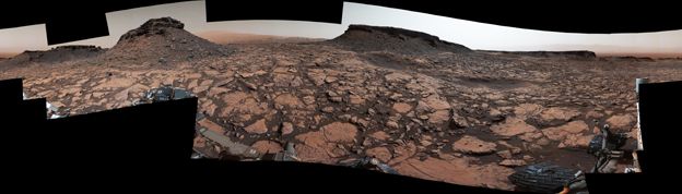
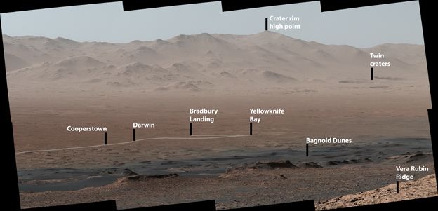
small grey pile of tailings. Image copyrightNASA/JPL-Caltech/MSSSLong drive: This panorama taken
with the rover's Mastcam shows Curiosity's 18.4km drive over the last 5
years from the Bradbury landing site to its current location on the Vera
Rubin Ridge (VRR). VRR was formerly known as Hematite Ridge due to the
high concentrations of the iron oxide mineral hematite detected here
from orbit. As hematite largely forms in the presence of water, this
location was a high-priority target for the Curiosity rover science team
to investigate in order to assess how the conditions in Gale Crater
changed over its geological history. This key location is the perfect
spot for Curiosity to spend its 2000th sol, and for all of us to look
back on the many discoveries made so far in the mission.
Curiosity rover: 2,000 days on Mars
Reviewed by sandra
on
March 23, 2018
Rating: 5


No comments: